
檔案:Oceanic pole of inaccessibility.png

覽幅:寛六〇〇高六〇〇微格。 他晰:寛二四〇高二四〇微格|寛四八〇高四八〇微格|寛九六〇高九六〇微格。
全幅 (微格九六〇矩九六〇,度:六三 KB,多用網際網路副檔名之型:image/png)
概

|
本圖片是以PNG、GIF或JPEG格式上傳。然而,其中包含的資料或訊息,應該重新建立成可縮放向量圖形(SVG)檔案,以更有效率或更準確的方式儲存。如有可能,請上傳本圖片的SVG格式版本。在上傳之後,請修改維基各姊妹計畫中所有使用舊版圖片的條目(列在圖像連結章節中),替換為新版圖片,並在舊圖片的描述頁中加入{{Vector version available|新圖片名稱.svg}}模板,同時移除本模板。
|
| 述 |
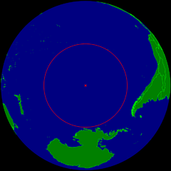
English: Spherical Earth centered on the oceanic pole of inaccessibility in the Southern Pacific ocean. The circle indicates the distance to the nearest landmasses (Antarctica, Easter Island and Ducie Island). The circle is deliberately a bit too small to ensure that the islands are still visible.
Deutsch: Erdkugel, zentriert auf dem ozeanischen Pol der Unzugänglichkeit im südlichen Pazifik. Der Kreis zeigt den Abstand zu den nächstgelegenen Landmassen (Antarktis, Osterinsel und Ducie). Der Kreis ist absichtlich ein wenig zu klein, damit die Inseln nicht verdeckt werden. |
| 期 | |
| 碼 | 己作 |
| 作者 | Timwi |
| 准 (重用此檔案) |
Public domain |
權
| 我,此作品的版權所有人,釋出此作品至公共領域。此授權條款在全世界均適用。 這可能在某些國家不合法,如果是的話: 我授予任何人有權利使用此作品於任何用途,除受法律約束外,不受任何限制。 |
檔誌
揀日尋檔。
| 日時 | 縮 | 度 | 用戶 | 註 | |
|---|---|---|---|---|---|
| 今 | 二〇一五年三月二四日 (二) 一〇時二一分 | | 九六〇矩九六〇(六三 KB) | RokerHRO | optipng -o7 -i0 → 28.12% decrease |
| 二〇〇八年七月二五日 (五) 二三時四〇分 |  | 九六〇矩九六〇(八八 KB) | Timwi | {{Information |Description= |Source= |Date= |Author= |Permission= |other_versions= }} | |
| 二〇〇八年七月二五日 (五) 二三時一四分 |  | 九五二矩九五二(三八 KB) | Timwi | {{Information |Description={{en|1=Spherical Earth centered on the oceanic en:pole of inaccessibility in the Southern Pacific ocean. The circle indicates the distance to the nearest landmasses (en:Antarctica, en:Easter Island and [[en:Ducie |
檔所繫者
下頁連本檔有2:
總文之用
下他共筆連本檔:
- ar.wikipedia.org上之用
- ast.wikipedia.org上之用
- az.wikipedia.org上之用
- ca.wikipedia.org上之用
- de.wikipedia.org上之用
- en.wikipedia.org上之用
- en.wikivoyage.org上之用
- es.wikipedia.org上之用
- et.wikipedia.org上之用
- eu.wikipedia.org上之用
- fa.wikipedia.org上之用
- frr.wikipedia.org上之用
- fr.wikipedia.org上之用
- fr.wiktionary.org上之用
- he.wikipedia.org上之用
- hu.wikipedia.org上之用
- id.wikipedia.org上之用
- it.wikipedia.org上之用
- ja.wikipedia.org上之用
- lb.wikipedia.org上之用
- lt.wikipedia.org上之用
- nl.wikipedia.org上之用
- nn.wikipedia.org上之用
- no.wikipedia.org上之用
- pl.wikipedia.org上之用
- pt.wikipedia.org上之用
- ro.wikipedia.org上之用
- sk.wikipedia.org上之用
- tr.wikipedia.org上之用
- uk.wikipedia.org上之用
- vi.wikipedia.org上之用
- www.wikidata.org上之用
- zh.wikipedia.org上之用
檢視此檔案的更多全域使用狀況。