
檔案:The Man in the High Castle Plausible World Map.png
全幅 (微格一五七七矩一一四一,度:四〇〇 KB,多用網際網路副檔名之型:image/png)

|
This map, as well as other fictitious maps, is fictitious or too incorrect (i.e. due to anachronism) to be used in real-life contexts (contemporary or historic). It may have some visual elements that are similar to official maps such as colors or certain layout features, but they are NOT official and don't have any official recognition. |
[[Category:]]
概
| 述 |
English: "The Man in the High Castle" is an alternate history novel by Philip K. Dick. It is set in a world in which the Axis powers have won World War II. This map is inspired by Dick's story and shows a plausible division of the world between Nazi Germany (dark brown), Imperial Japan (dark red) and their respective allies. However, the map is much more precise than the book describes.
https://web.archive.org/web/20191202005150/http://www.high-castle-world-map.com:80/ |
| 期 | |
| 碼 | 己作 |
| 作者 | RobintheHighCastle |
| 准 (重用此檔案) |
權
我,本作品的著作權持有者,決定用以下授權條款發佈本作品:
此檔案採用創用CC 姓名標示-相同方式分享 4.0 國際授權條款。
- 子可:
- 享 – 複製、發佈和傳播本作品
- 重改 – 創作演繹作品
- 惟需遵照下列條件:
- 享 – 您必須指名出正確的製作者,和提供授權條款的連結,以及表示是否有對內容上做出變更。您可以用任何合理的方式來行動,但不得以任何方式表明授權條款是對您許可或是由您所使用。
- 共享 – 如果您利用本素材進行再混合、轉換或創作,您必須基於如同原先的相同或兼容的條款,來分布您的貢獻成品。
檔誌
揀日尋檔。
| 日時 | 縮 | 度 | 用戶 | 註 | |
|---|---|---|---|---|---|
| 今 | 二〇二一年一〇月二九日 (五) 一四時五五分 | 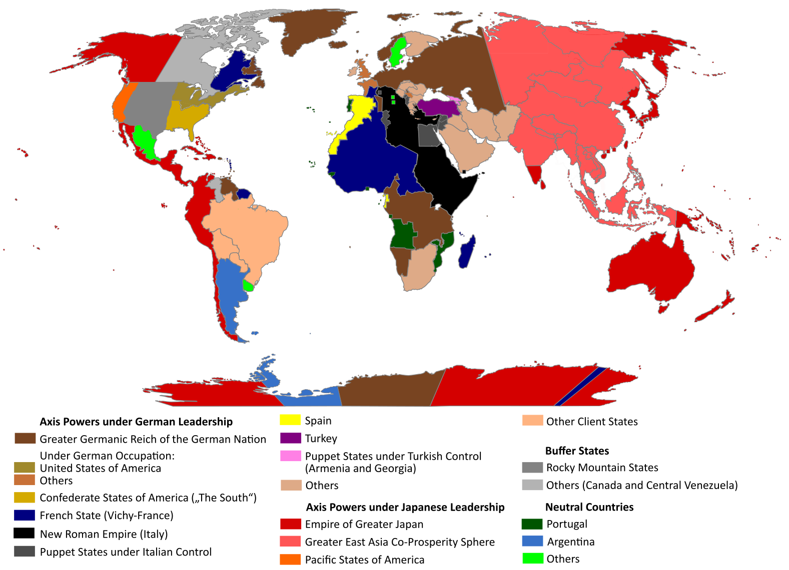 | 一五七七矩一一四一(四〇〇 KB) | Saltner67 | Added the portoguese colonies Cabinda and Ajuda since they would still have existed in this world. |
| 二〇二一年六月二〇日 (日) 〇八時〇五分 |  | 一六一三矩一一四三(四一七 KB) | Gernsback67 | Changed "Greater Asian Co-Prosperity Sphere" in "Greater East Asia Co-Prosperity Sphere", which is correct. | |
| 二〇二〇年一〇月一六日 (五) 一五時三〇分 |  | 一六一一矩一一三八(四一八 KB) | Saltner67 | Restored the latest version. Please do not revert any changes, which have been made to this file so far, without any communication with the author of the map. All changes made here have been initialized by the author and are a result of the same process which has led to the creation of the map in the first place. | |
| 二〇二〇年一〇月一六日 (五) 〇八時二五分 |  | 一六二一矩一一三七(三九二 KB) | Gooduserdude | RV Original research: this image is based on a source and should not be altered | |
| 二〇二〇年三月二九日 (日) 一四時一五分 |  | 一六一一矩一一三八(四一八 KB) | Saltner67 | Improved the accuracy of borders of Mongolia and Manchukuo. | |
| 二〇二〇年三月二七日 (五) 一五時五八分 |  | 一六〇七矩一一三八(四一八 KB) | Saltner67 | Enlarged Manchukuo and added the puppet states of Yakutia and Krasnoyarsk/Irkutsk after more research on Kantokuen. | |
| 二〇二〇年三月一二日 (四) 一九時〇七分 |  | 一六一二矩一一四三(四一一 KB) | Saltner67 | Moved the Swiss Canton of Valais from Germany to Italy, as has been prepared in the plans for Operation Tannenbaum. | |
| 二〇二〇年二月八日 (六) 一八時五七分 |  | 一六〇五矩一一三九(四一一 KB) | Saltner67 | Reinserted the territories of Tunisia,Greece, Crete and Cyprus after research on the Italian plannings and Greece in WWII. | |
| 二〇一九年一一月二一日 (四) 一三時二一分 |  | 一六一一矩一一三三(四〇九 KB) | Gernsback67 | Enlarged Mongolia again after more research on pan-mongolism. | |
| 二〇一九年九月二一日 (六) 一五時一三分 |  | 一六一〇矩一一三七(四〇八 KB) | Saltner67 | unified Mongolia, enlarged Manchukuo and Thailand, re-inserted the real-life borders of Laos and Vietnam after research on Demchugdongrub, Kantokuen, Thailand and Indochina in WWII |
檔所繫者
下頁連本檔:
總文之用
下他共筆連本檔:
- ar.wikipedia.org上之用
- cs.wikipedia.org上之用
- da.wikipedia.org上之用
- de.wikipedia.org上之用
- en.wikipedia.org上之用
- en.wikiquote.org上之用
- es.wikipedia.org上之用
- gl.wikipedia.org上之用
- he.wikipedia.org上之用
- hu.wikipedia.org上之用
- it.wikipedia.org上之用
- ja.wikipedia.org上之用
- ko.wikipedia.org上之用
- lt.wikipedia.org上之用
- nl.wikipedia.org上之用
- pl.wikipedia.org上之用
- pt.wikipedia.org上之用
- ro.wikipedia.org上之用
- ru.wikipedia.org上之用
- th.wikipedia.org上之用
- uk.wikipedia.org上之用
- zh.wikipedia.org上之用