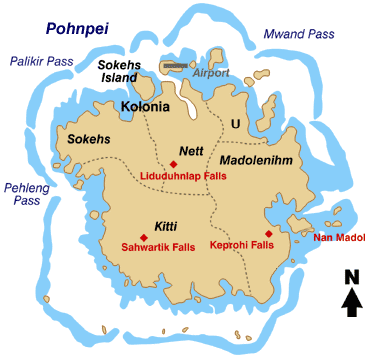
檔案:Pohnpei map.gif
Pohnpei_map.gif (微格三六六矩三五六,度:一九 KB,多用網際網路副檔名之型:image/gif)
檔誌
揀日尋檔。
| 日時 | 縮 | 度 | 用戶 | 註 | |
|---|---|---|---|---|---|
| 今 | 二〇〇八年四月七日 (一) 一九時五九分 |  | 三六六矩三五六(一九 KB) | Scanlan | {{Information |Description=Map of the Island of Pohnpei, in the Federated States of Micronesia |Source=http://www.doi.gov/oia/press/2008/04042008.html |Date=April 4, 2008 |Author= United States government Department of the Interior |Permission= |other |
檔所繫者
下頁連本檔:
總文之用
下他共筆連本檔:
- ar.wikipedia.org上之用
- bo.wikipedia.org上之用
- ca.wikipedia.org上之用
- cs.wikipedia.org上之用
- de.wikipedia.org上之用
- en.wikipedia.org上之用
- eo.wikipedia.org上之用
- es.wikipedia.org上之用
- fa.wikipedia.org上之用
- fr.wikipedia.org上之用
- gl.wikipedia.org上之用
- it.wikipedia.org上之用
- ja.wikipedia.org上之用
- ka.wikipedia.org上之用
- ko.wikipedia.org上之用
檢視此檔案的更多全域使用狀況。


