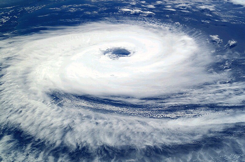
العربية: قبل سنة 2004م، سُجِّل ظُهور عاصفتين إستوائيتين فقط في حوض المُحيط الأطلسي الجنوبي، دون أن تظهر أيَّة أعاصير. على أنَّ إحدى العواصف الصغيرة التي ظهرت مُقابل شواطئ البرازيل الجنوبيَّة تطوَّرت حتَّى أصبحت لها خصائص العاصفة الاستوائيَّة واستمرَّت تتضخَّم مع توجُهها نحو الغرب. وسُرعان ما أصبح لِهذه العاصفة عينٌ مركزيَّة ووصلت قُوَّتها إلى قُوَّة الإعصار بِحسب الظاهر يوم الجُمُعة 26 آذار (مارس)، قبل أن يضرب اليابسة في أواخر يوم السبت 27 آذار (مارس) 2004م.
أُعلم طاقم محطَّة الفضاء الدوليَّة بِهذه العاصفة فالتقطوا لها صُورًا مُمتازة ما أن ضربت اليابسة في ولاية
سانتا كاترينا بِجنوب البرازيل (بناءً على هذا أُطلق على العاصفة تسمية إعصار كاترينا). لاحظ كيف أنَّ حركة الأعاصير في النصف الجنوبي من الكُرة الأرضيَّة هي باتجاه عقارب. يُمكن رُؤية الساحل البرازيلي أسفل الغُيُوم في الزاوية العُليا اليُسرى من الصُورة.
English: Before the year 2004, only two tropical cyclones had ever been noted in the South Atlantic Basin, and no hurricane. However, a circulation center well off the coast of southern Brazil developed tropical cyclone characteristics and continued to intensify as it moved westward. The system developed an eye and apparently reached hurricane strength on Friday, March 26, before eventually making landfall late on Saturday, March 27, 2004.
The crew of the International Space Station was notified of the cyclone and acquired excellent photographs of the storm just as it made landfall on the southern Brazilian state of
Santa Catarina (the storm has been unofficially dubbed “
Cyclone Catarina”). Note the clockwise circulation of Southern Hemisphere cyclones, the well-defined banding features, and the eyewall of at least a Category 1 system. The coastline is visible under the clouds in the upper left corner of the image.
Français : Avant 2004, aucun cyclone n'a jamais été observé dans l'Atlantique sud. Cependant, au cours du mois de mars 2004, un système dépressionnaire situé loin au large du Brésil a développé toutes les caractéristiques d'un ouragan tout en se déplaçant vers l'ouest. Le 26 mars, l'ouragan forme un œil bien défini ce qui correspond au niveau Cyclone. Le 27 mars 2007 au soir, il atteint les côtes brésiliennes.
L'équipe de la station spatiale internationale, informée du développement de ce cyclone inhabituel, a pu prendre de belles photos du cyclone juste au moment ou il a touché terre dans l'état brésilien de
Santa Catarina (D’où son nom officieux de
Cyclone Catarina. Le cyclone présente sur cette photo un œil bien défini, et tourne dans le sens des aiguilles d'une montre. La côte est visible en haut à gauche de l'image.


