
檔案:Somalia Numbered Regions.png
覽幅:寛四八〇高六〇〇微格。 他晰:寛一九二高二四〇微格|寛五一二高六四〇微格。
全幅 (微格五一二矩六四〇,度:二〇 KB,多用網際網路副檔名之型:image/png)
| 述 |
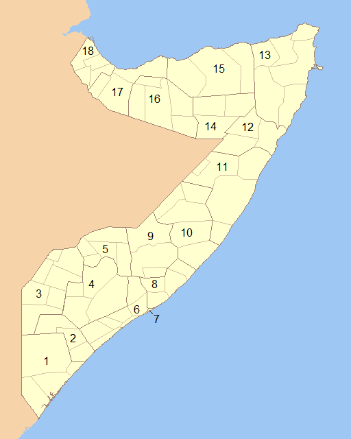
English: Blank map of Somalia showing the regions (numbered) and districts in detail together. 1- Lower Juba 2- Middle Juba 3- Gedo 4- Bay 5- Bakool 6- Lower Shabele 7- Banaadir 8- Middle Shabele 9- Hiiraan 10- Galguduud 11- Mudug 12- Nugaal 13- Bari 14- Sool 15- Sanaag 16- Togdheer 17- Woqooyi Galbeed 18- Awdal |
||
| 期 | |||
| 碼 | Modified File:Somalia Regions and Districts.png to create image | ||
| 作者 | Wiz9999 | ||
| 准 (重用此檔案) |
|
||
| 其他版本 | File:Somalia Regions and Districts.png |
檔誌
揀日尋檔。
| 日時 | 縮 | 度 | 用戶 | 註 | |
|---|---|---|---|---|---|
| 今 | 二〇〇九年六月六日 (六) 〇〇時一三分 | | 五一二矩六四〇(二〇 KB) | Wiz9999 | {{Information |Description={{en|1=Blank map of Somalia showing the regions (numbered) and districts in detail together.}} |Source=Modified File:Somalia Regions and Districts.png to create image |Author=Wiz9999 |Date=2009-06-05 |Permi |
檔所繫者
下頁連本檔:
總文之用
下他共筆連本檔:
- als.wikipedia.org上之用
- ar.wikipedia.org上之用
- azb.wikipedia.org上之用
- bg.wikipedia.org上之用
- bs.wikipedia.org上之用
- da.wikipedia.org上之用
- de.wikipedia.org上之用
- el.wikipedia.org上之用
- en.wikipedia.org上之用
- es.wikipedia.org上之用
- eu.wikipedia.org上之用
- fa.wikipedia.org上之用
- is.wikipedia.org上之用
- it.wikipedia.org上之用
- ko.wikipedia.org上之用
- li.wikipedia.org上之用
- mk.wikipedia.org上之用
- mzn.wikipedia.org上之用
- no.wikipedia.org上之用
- pl.wikipedia.org上之用
- ps.wikipedia.org上之用
- pt.wikipedia.org上之用
- ro.wikipedia.org上之用
- ru.wikipedia.org上之用
- so.wikipedia.org上之用
- trv.wikipedia.org上之用
- tr.wikipedia.org上之用
- ur.wikipedia.org上之用
- zh.wikipedia.org上之用