
檔案:CEM-44-La-Chine-la-Tartarie-Chinoise-et-le-Thibet-1734-Amur-2572.jpg
全幅 (微格二四九二矩一八七二,度:一點八五 MB,多用網際網路副檔名之型:image/jpeg)
| 述 |
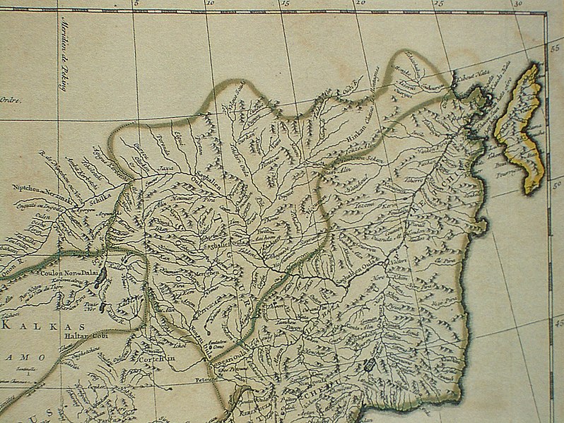
Français : Carte la plus generale et qui comprend la Chine, la Tartarie Chinoise, et le Thibet. Dressee sur les cartes particuliers des RR PP Jesuites, par le Sr. d'Anville..., qui ya joint le pays compris entre Kashgar et la mar Caspienne, tire des geographes et des historiens orientaux
English: A most general map, including China, Chinese Tartary, and Tibet, based on individual maps of the Jesuit fathers. The map gives 1734 as the year, but the modern HKUST publishers say 1737
English: Fragment: Amur River area
"D’Anville’s maps of China were based on a survey of the Chinese empire that was ordered by the emperor in 1708 and carried out by the Chinese, but under the supervision of Jesuit priests resident in China. The detail about the interior of China was far superior to any previous Western map or atlas. D’Anville’s work remained a standard Western source for the geography of China and adjacent regions until well into the 19th century, when it finally was superseded by more accurate maps." — (World Digital Library) |
| 期 | 1734, according to the map itself (although the modern publishers say 1737) |
| 碼 |
English: An antique map from the Special Collection "China in Maps" of the Hong Kong University of Science and Technology Library, reproduced by the HKUST Library in the book "China in European Maps", Hong Kong, 2003. ISBN 962-86403-9-9.
Русский: Старинная карта из специальной коллекции Библиотеки Гонконгского научно-технического университета. Опубликована этой библиотекой в книге "China in European Maps" (Китай на европейских картах), Гонконг, 2003. ISBN 962-86403-9-9, тиражом 1000 экз. См. также каталог выставки, Special Collection "China in Maps".
Plate 44 |
| 作者 | |
| 准 (重用此檔案) |
Author died more than 70 years ago - public domain |
| 其他版本 |
Entire map:  |


|
本作品在其來源國以及其他著作權期限是作者逝世後100年或以下的國家與地區屬於公有領域。 | |
| 此作品無已知的著作權限制,亦不受所有相關和鄰接的權利限制。 | |
| Annotations | This image is annotated: View the annotations at Commons |
檔誌
揀日尋檔。
| 日時 | 縮 | 度 | 用戶 | 註 | |
|---|---|---|---|---|---|
| 今 | 二〇一〇年六月七日 (一) 〇一時〇七分 |  | 二四九二矩一八七二(一點八五 MB) | Ras67 | losslessly cropped with Jpegcrop |
| 二〇〇九年三月二二日 (日) 一三時三二分 |  | 二五六〇矩一九二〇(二點〇七 MB) | Vmenkov | {{Information |Description={{fr|Carte la plus generale et qui comprend la Chine, la Tartarie Chinoise, et le Thibet. Dressee sur les cartes particuliers des RR PP Jesuites, par le Sr. d'Anville..., qui ya joint le pays compris entre Kashgar et la mar Casp |
檔所繫者
下頁連本檔:
總文之用
下他共筆連本檔:
- ast.wikipedia.org上之用
- be-tarask.wikipedia.org上之用
- be.wikipedia.org上之用
- bg.wikipedia.org上之用
- cs.wikipedia.org上之用
- en.wikipedia.org上之用
- eo.wikipedia.org上之用
- es.wikipedia.org上之用
- et.wikipedia.org上之用
- eu.wikipedia.org上之用
- fa.wikipedia.org上之用
- fr.wikipedia.org上之用
- hr.wikipedia.org上之用
- id.wikipedia.org上之用
- ja.wikipedia.org上之用
- mn.wikipedia.org上之用
- nl.wikipedia.org上之用
- nn.wikipedia.org上之用
- no.wikipedia.org上之用
- pl.wikipedia.org上之用
- pt.wikipedia.org上之用
檢視此檔案的更多全域使用狀況。